Herring Scrap 33: Pen Pals Pt. 1 (An Alaska Public Records Act Request)

Back in Scrap 30, I sent a letter to ADF&G about why I think the recent Unfished Biomass study is falsely premised and needs revision - I'd noticed a signal in the data that suggested that the data might not have been based on observational studies for several years early in the time series in ways that seemed likely encourage over-fishing at low abundance in the future. I wanted to share an update of where that thread has gone since.
I heard back from one of the authors of that study a couple weeks after I sent the letter (in November): they wrote to say that they'd look into it. They seemed annoyed. They acknowledged that this wasn't the first time they'd heard from me: "based on our past correspondence, we recognize that you have concerns with ADF&G data in the 1970’s, and now also in the 1980’s and 1990’s". They referred me to their response to a previous missive I'd sent on April 2, 2019, and which they replied to nearly a year later on March 4, 2020. In that earlier letter, I'd focused on describing the extremely conspicuous issues with uncritically comparing modern data with their 1970's data, as they were then doing and still are.
In their November response, they reminded me that in their March 2020 response, "we shared that we agree with the importance of understanding how survey methods for monitoring herring populations have changed over time. However, we also described in detail why, based on all three survey methods the department has used to assess Sitka Sound herring (lineal miles of shoreline with spawn, hydroacoustics surveys, and scuba-dive surveys for egg deposition), we disagree that the department has misrepresented the relative biomass of herring in Sitka Sound and that they are irresponsibly and intensely biased."
Their email continued: "Regarding your conclusion that the data used from those three decades are fabricated and that the surveys did not exist [nb. This is absolutely not what I've said or concluded. I've avoided making sweeping generalizations across decades and in fact my whole campaign has been about trying to differentiate and account for the various modes of surveying over the years] the extensive compilation of department reports available through the department website (Publications Search - Sport Fish - ADF&G), provide evidence (survey methods, estimates, and details) of surveys being conducted. Similarly, these reports provide hydroacoustic and spawn deposition estimates for those decades that contrast with your suggestion that decades of estimates are based solely on an assumption of pounds of herring per nautical mile. References cited in our recent report (Roberts et al. 2024) provide details about some of the specific estimates. Please let me know if resending our email from 2020 may be of help."
I did not need them to re-send the email from March 2020, as I had re-read it before sending my letter about the Unfished Biomass study. I consider their assertions in it, and their recent re-assertions about it, indefensible and unsubstantiated and rather ridiculous. And so I replied with a few clarifications to allay mischaracterization of my claims, and I requested some data missing from their publicly available historic reporting. In the weeks that followed, I received no further reply to that request.
Filing a Request under the Alaska Public Records Act
That non-response prompted me to file an Alaska Public Records Act (the State equivalent of the Freedom of Information Act) request in December. You can read my entire request here, if you like; in it, I ask for a variety of information missing from reporting for the years 1976-1991.
The way these things work in Alaska is that you have to pay the hourly cost of the lowest-salaried employee who could fulfill the request. I'm not here to go broke clarifying State science, and so I requested a fee waiver ("Per 2 AAC 96.370 and 2 AAC 96.470, I request fee relief, given that the records are likely to contribute significantly to the public’s understanding of the operations or activities of the State of Alaska. My findings from this request will help me provide accurate context in public comment for the Southeast Alaska Board of Fisheries meeting in January when the threshold level (and thus the Unfished Biomass described in the Simulation Study) will be discussed in the context of a number of proposals, in particular ADF&G’s Proposal 171.") I heard back that my fee waiver request hadn't been granted but that I could narrow the request down to something that could be fulfilled in 5 free hours of staff labor, and so that's what I did.
I narrowed down my request to the following:
I'll ask that those hours be focused on the years 1984, 1985, and 1986. For those years, I am most interested in methodology/formulae by which the average transect width and average egg density figures were derived mathematically from individual transect findings. Each of those years has an identical relationship of nautical miles of spawn : egg deposition, which suggests a tenuous relationship to actual thorough observational data. I would like any documentation that would help me understand why the survey results from those years resulted in the same [eggs per mile of spawn] value. As far as transect maps are concerned, smartphone photos of the maps would be adequate for my needs. If there is remaining time available after seeking out that content for 84/85/86, then I ask that time remaining time be applied to years 1988 and 1989.
They received my abridged request well, and I received a couple hundred pages worth of documents earlier this month. You can browse them here, if you'd like. I'm grateful that they turned the request around in so timely a fashion for me.
What I received
My record request resulted in data from 1984, 1985, 1986, 1988, and 1989, as well as a single file from 1991. I received much of what I asked for, but a lot of what I need to make sense of things is still missing. I think it is reasonable to assume that if it wasn't included in the files that were shared with me, then it wasn't - and won't be - found (I don't extend that assumption to 1987 and 1991, as those years weren't formally part of my abridged request, and there's surely more for those years). I made this table to illustrate what I did and didn't receive:
| Flight Paths | Aerial Survey Logs | Transect Chart | Transect Raw Data Sheets | Data To Biomass Calc | Spawn Maps By Day | Cumulative Spawn Maps | |
| 1984 | NO | YES | YES | YES | YES | YES | YES |
| 1985 | NO | YES | YES | YES | NO | YES | YES |
| 1986 | NO | YES | YES | NO | NO | YES | YES |
| 1987 | NO | NO | NO | NO | NO | NO | NO |
| 1988 | NO | YES | NO | YES | NO | NO | YES |
| 1989 | NO | YES | NO | NO | NO | NO | YES |
| 1991 | NO | NO | NO | YES | YES | NO | NO |
Below, I've assembled a gallery showing excerpts of different components from the documents for the most complete year - 1984 - to give you a sense of what all this stuff looks like; I describe the components briefly in the caption below:
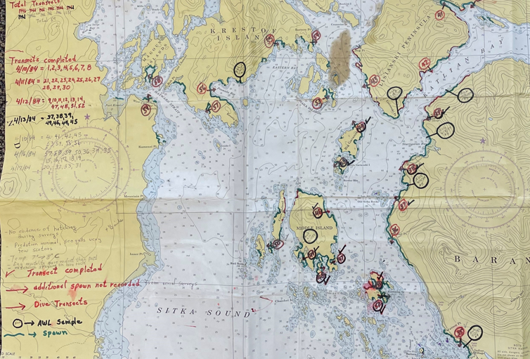
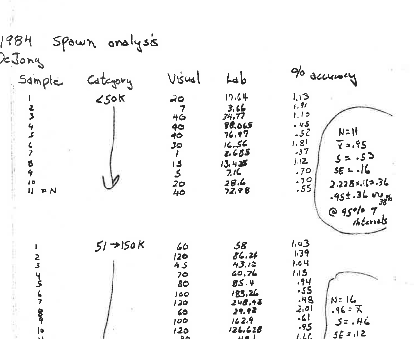
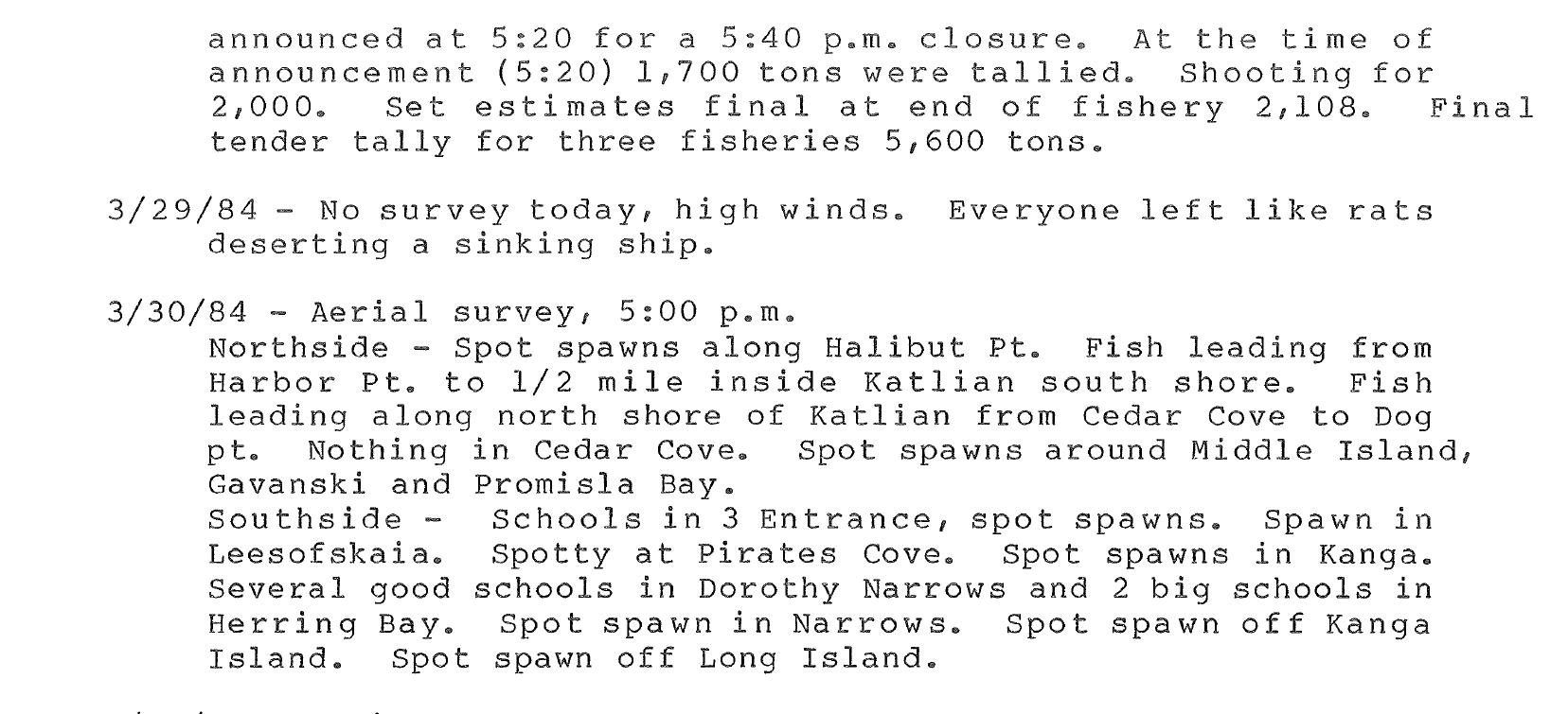
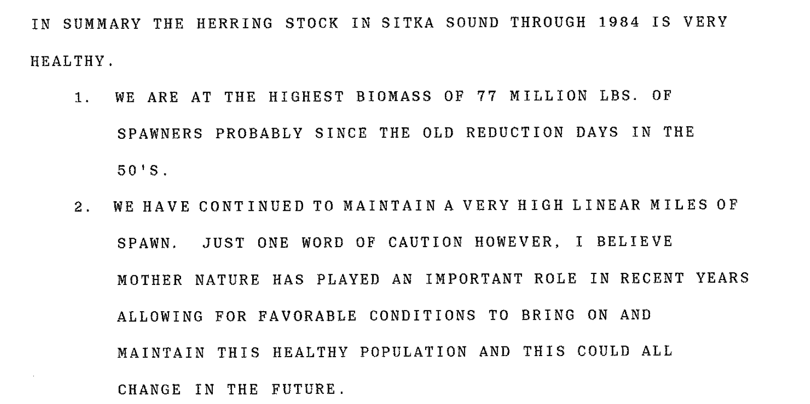
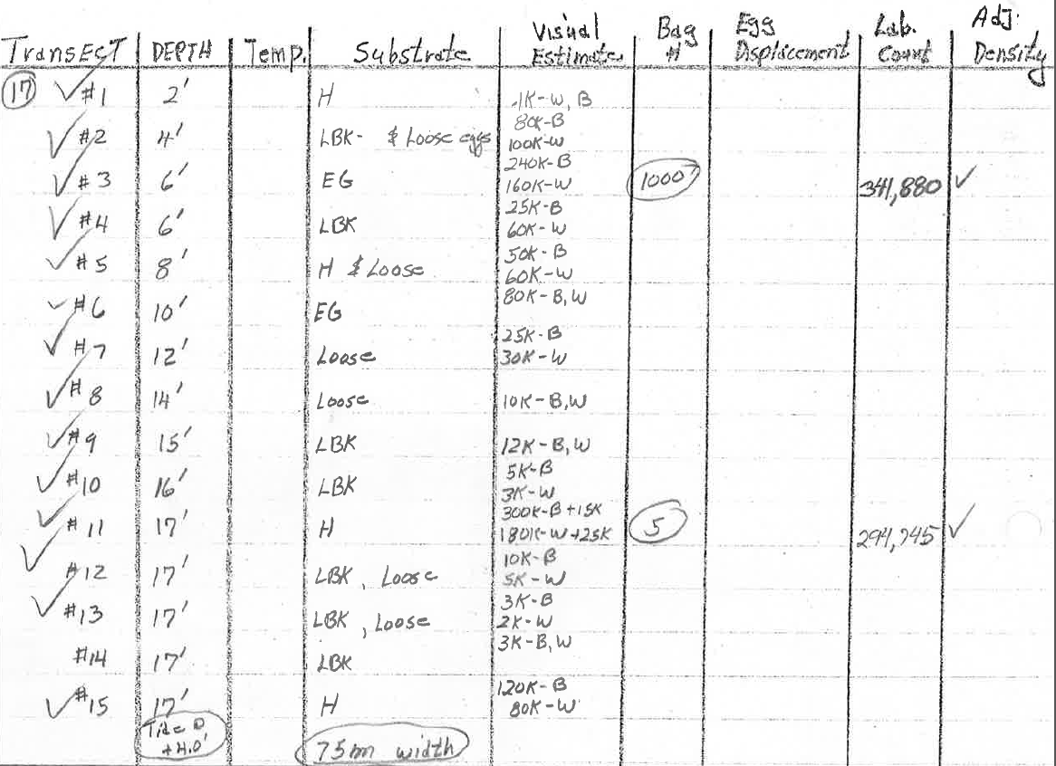
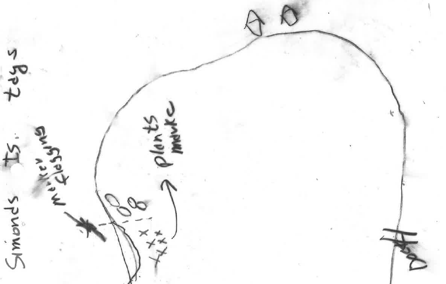
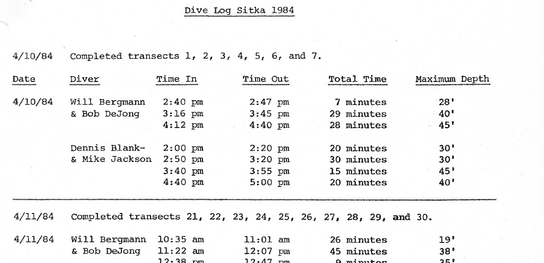

From left to right, top to bottom: 1. part of a transect map showing where spawning has occurred and where dive surveys were conducted, with a transect number corresponding to each dive survey location; 2. part of a spawn analysis for one diver, comparing visual estimates to laboratory estimates for samples of a certain size in order to develop a correction coefficient for that diver's other visual estimates; 3. an excerpt of the aerial survey logs and daily notes for the season; 4. an excerpt of key findings from the end-of-season memo; 5. a chart from the data logs for transect #17 indicating the visual estimates for each quadrat sample along that transect, along with comparative lab counts for certain samples; 6. a doodle marking the spot where a sampled piece of macrocystis lived; 7. an excerpt from the dive log indicating which transects occurred when and with which divers; 8. part of a more detailed chart indicating where spawning occurred for each day surveyed.
What I've found through this record request is somewhat different than what I expected - archival digs wouldn't be fun if they didn't work that way. I think I expected that the spawn deposition surveys for 1984, 1985, and 1986 would be similarly incomplete to those of 1981 - the other year that features the same strangely linear relationship between nautical miles of spawn and total egg count that I described in scrap 30. I'd figured that data for those years wasn't available because there was some kind of capacity issue at play in the mid-80's because of Alaska's bust economy at the time; I wondered if the Department might not be able to track down the relevant data at all. I wondered if the surveys didn't even really happen.
As I looked through the files that I'd been provided, it became clear to me that those assumptions were a bit off: the Department had indeed conducted relatively thorough spawn deposition surveys within the management area in at least some of those years.
What I found, instead, is that, despite doing thorough studies, the data that the department refers to for those years probably isn't based on the data that resulted from those studies.
I'll explain how I came to that conclusion, among other findings from this Alaska Public Records Act request, in the next couple scraps.